My climbing plans for the fall of 2025 were completely different just a few months ago, and the idea of returning to the Greater Ranges was still a distant dream for some future year. But in June, I got a message from my good friends and top Polish alpinists, Michał Czech and Wadim Jabłoński: “We’ve got permits for two unclimbed 6000ers in the Karakoram. It’s kind of last minute, but we’re looking for a third partner — you’re the first one we’re asking.” That kind of offer was hard to turn down. After clearing my calendar and sorting out the logistics, I happily said yes.
Dozens of unclimbed peaks, endless potential, pure adventure - This is every alpinist’s dream.
The sandstone season in Adršpach flew by, and before I knew it, the second half of August — and our departure — had arrived. Besides the climb itself, another huge draw of this expedition was our destination: the Saltoro Range, southwest of the Siachen Glacier. Until very recently, this region was practically off-limits because of the complex geopolitical situation. Our basecamp was set in the Gyong Valley, right next to the so-called Line of Control — the de facto border between the Indian- and Pakistani-controlled parts of Kashmir.
For decades, these two powers have been in conflict over this territory, maintaining heavy military presence throughout the region. There are dozens of army outposts scattered through the mountains, reaching altitudes up to 5500–6000 m. Because of that, the whole area had been closed to any tourism since the late 1970s.
Last year, Pakistan opened it to civilians for the first time in more than 45 years — and we were the first foreigners to set foot in these mountains since then. In many places, we were literally the first humans ever. This is every alpinist’s dream: dozens of unclimbed peaks, endless potential, pure adventure.
Of course, unexplored terrain comes with uncertainty. We left for the expedition with minimal information. Satellite images and maps give a rough idea of relief and steepness of the face, but they can be misleading — they don’t show things like seracs and other important details.
We had permits for two dominant unclimbed peaks in the Gyong Valley — Gharkun (6600 m) and Chumik Kangri (6754 m). In Pakistan, any climb above 6500 m requires a legal permit, and especially in this region, it’s basically impossible to climb without one due to frequent military checkpoints on the way to basecamp.
We didn’t want to bet everything on one mountain, so we paid for two permits, even though we knew the chances of opening new routes on both were slim to none.
The paradox of this area is that, despite its remoteness, the military has built a surprisingly good infrastructure. Thanks to that, our basecamp at 4100 m was fully reachable by jeep, and only about 500 m from an army post. As soon as the basecamp was set up, we got moving — acclimatization began the next day. We did a few day trips to explore the valley and finally get a first look at our intended faces.
At first, Chumik Kangri was hidden in clouds, so our first visible objective was the massive 1700-meter north pillar of Gharkun — beautiful and intimidating.
From satellite photos, we had already imagined a line up the central pillar, but the real thing was far more imposing than Google Earth could ever suggest. The wall had several big seracs hanging above — closer than we’d like. A pillar usually means relative safety, but not always; if some ice would break at the wrong time, it could have bad consequences. We quickly realized that proper acclimatization to 6000 m would be impossible in the Gharkun valley apart from the north face itself.
Acclimatization begins
Following days we turned our attention toward Chumik Kangri’s valley, where we planned to try the south face. This 1100-meter wall, clean and serac-free, looked much friendlier than Gharkun, and after a few days of scoping, we decided Chumik would be our Plan A. The only problem — how to get to the base of the wall. At first, it wasn’t even clear whether it was possible. The lower wall was guarded by a huge vertical cliff band, and to the left was a nasty icefall we ruled out immediately. For a few days we wandered around, taking in the scenery and getting used to the thin air.
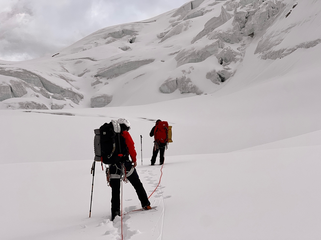
During the first round of acclimatization we established an ABC at around 5000 m, spent two nights there, and made hikes up to 5400 and 5800 m while exploring possible access routes to the upper glacier. After that rotation, we returned to BC for rest — just in time for four days of bad weather, which dumped up to 40 cm of new snow higher up.
Weather complicates plans
When the skies finally cleared, we headed out for our second and final acclimatization round, hoping to sleep at least at 6000 m. By sheer luck we found a gully system of ramps and ledges piercing the otherwise impenetrable barrier. It went surprisingly easily — almost no technical climbing — but it was brutally exhausting with heavy packs. We carried loads to move the ABC onto the upper glacier and stash a gear cache. After a night in the new ABC at 5600 m, we went higher. The plan was to sleep at least at 6000 m, ideally even higher. Around noon we set up a bivy at 6100 m, but a sudden weather change made it impossible to go any further. After 20 hours lying in the tent The next morning through snowfall and zero visibility, we decided to descend. We managed to get down only thanks to the GPS track on our watches.
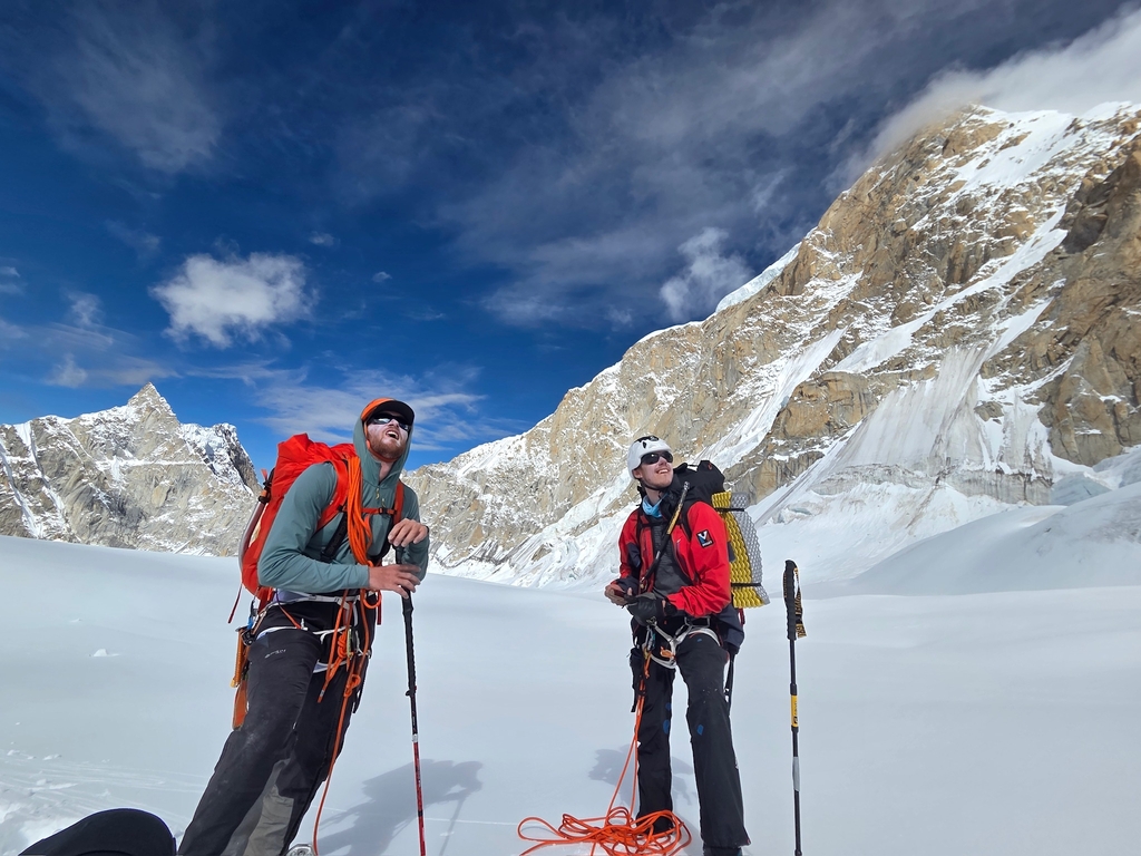
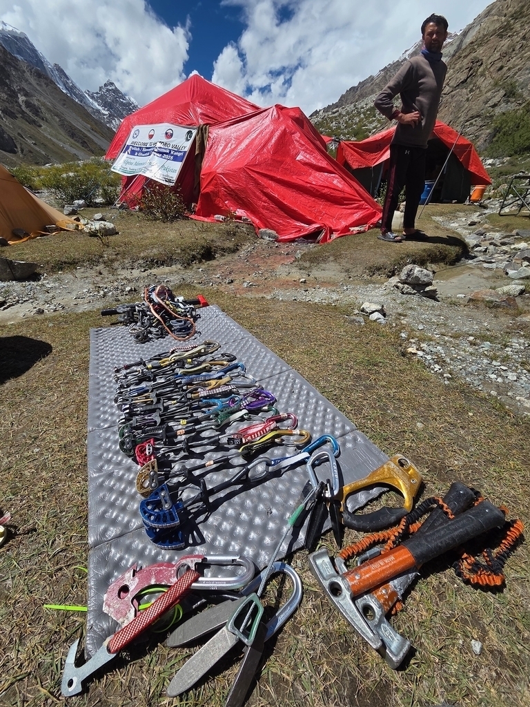
Back in basecamp the next day, we were ready to rest — the weather didn’t look promising. But then, after updating our inReach forecast, we suddenly saw a 5–6-day weather window starting the next morning. Exactly what we needed — but we had to move fast. Our Polish meteorologist confirmed the forecast, and that was it: game on! Our plan was clear from the start — pure alpine style, no fixed ropes, no support. That’s the only way we climb, and the only way these mountains should be climbed. From basecamp to summit, it was just the three of us — self-sufficient, carrying everything, no compromise. The approach to the upper glacier ABC took two days. Before early-morning starts on big alpine climbs, I usually sleep poorly, but that night I was surprisingly calm — at peace, even — and genuinely excited for the unknown ahead.
Game on
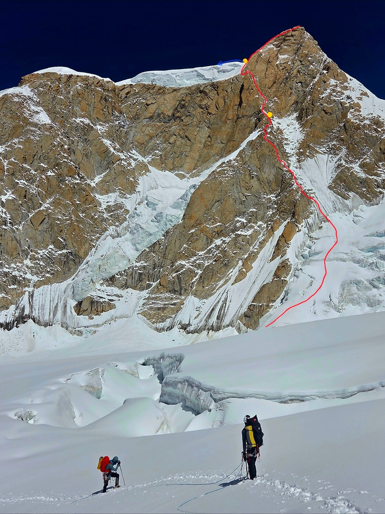
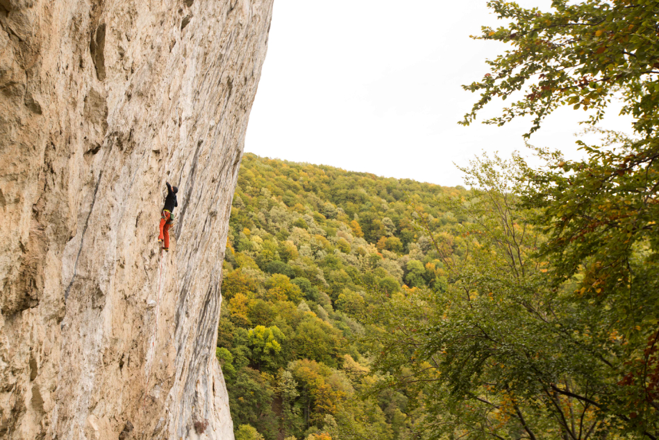
Alarm 1:00 a.m. — by 3:00 we were moving out from the bivy. The route began with easy snow slopes, gradually steepening into several pitches of 70–80° ice. We climbed this section deliberately early, before sunrise, to avoid rockfall. After a few pitches the line veered left, gaining the safety of a buttress. The higher we got, the steeper it became. Pitch by pitch we moved upward — solid mixed climbing, mostly around M5, and with heavy packs and thin air it was no joke. Aside from a few looser sections, the climbing was on perfect golden granite — pure Karakoram gold, the stuff you dream about. Nepal can only envy rock like this. By mid-afternoon we reached our planned bivy — a snowy ridge where we hoped to carve out a tent ledge. The headwall above looked intimidating, so we decided to stop there. After an hour of chopping, we had a beautiful ledge for our two-person tent — tight for three, but comfortable enough. The night was calm.
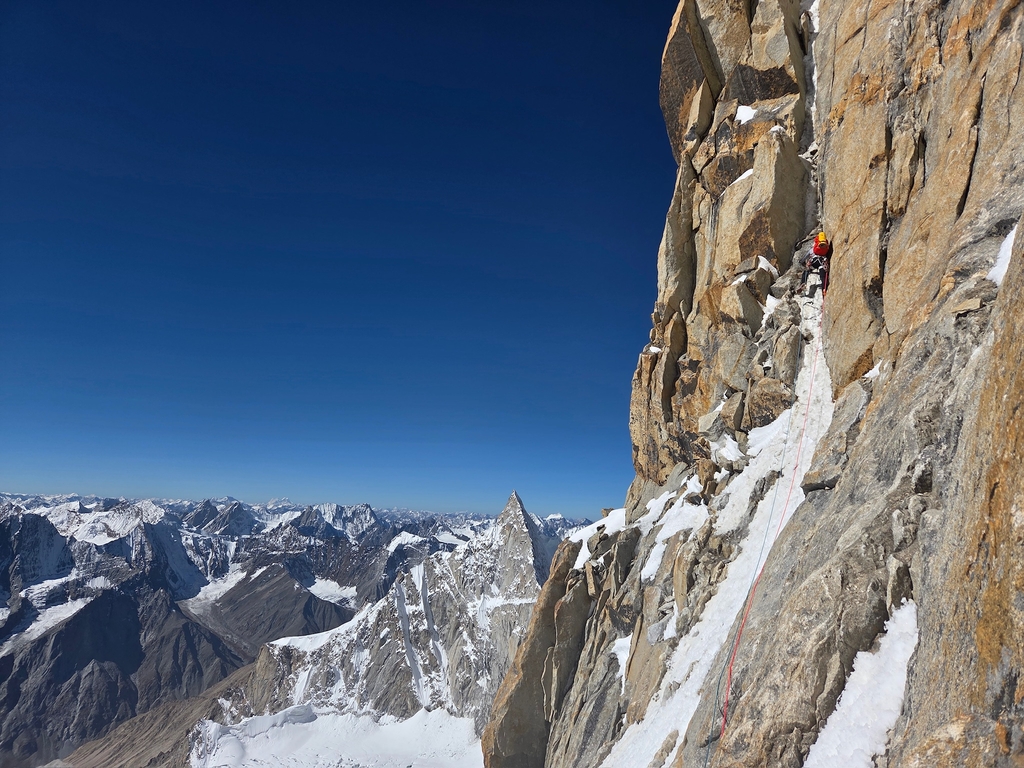
The next morning we waited for the sun to hit the bivy around 7 a.m. — a welcomed morale boost. I led the first few pitches; everything went smoothly, though evry pitch demanded tons of effort. We were now around 6250 m, and for both Michał and me it was our first time climbing technically at that altitude. Everything moves slower than in the Alps. The mind wants to push harder but the body protests — things have a different pace up here.
After a few pitches, Michał took the sharp end. He drew the short straw — the crux block — but handled it brilliantly. On one wet, and hard pitch he resorted to a bit of aid (A1), using the etriers we’d debated bringing — good call. Aside from that single section (which would probably go free at around 6c in rock shoes if dry), we climbed everything team onsight.

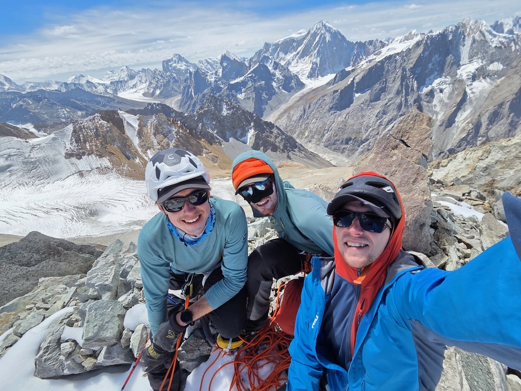
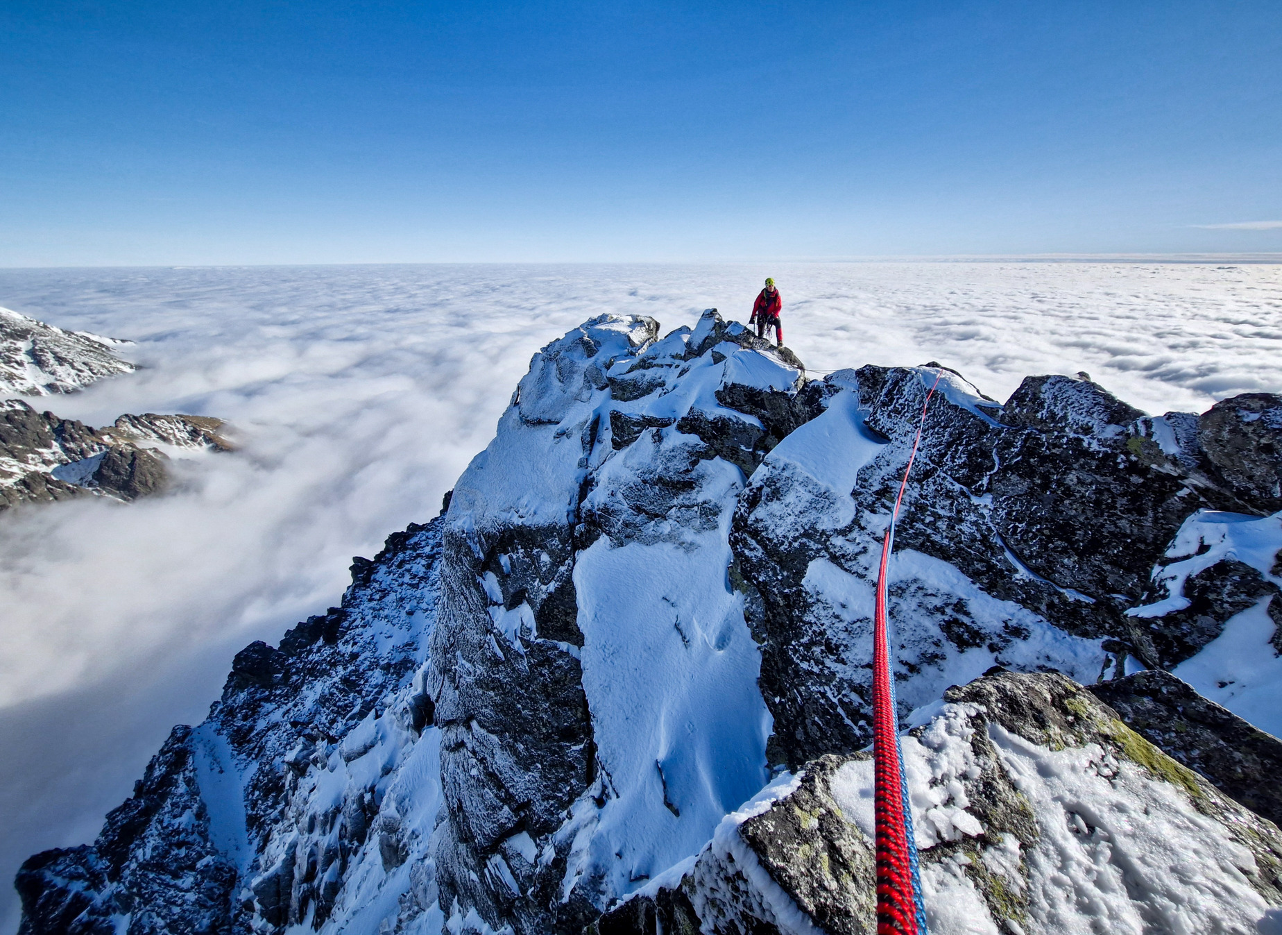
Higher up came the biggest question mark: from the top of the pillar we had to traverse from hard rock terrain into an easier ice couloir to the right of a large serac, leading to the summit plateau. We weren’t sure if it would go. Here Michał showed his brilliant sense of route-finding — from the top of the pillar, in wildly exposed terrain with a kilometer of air below, he traversed and downclimbed into a big corner system on the left. Two pitches later, we could rap diagonally into easier ground. From there, the bivy ledge on the summit plateau was just 100 m away — though at 6600 m it felt like 500. Darkness fell and temps plummeted. We reached the ledge with frozen fingers but no real issues, and we knew — tomorrow we’d stand on the summit. The night was cold, but crammed together like sardines in our 2×1 m tent, it wasn’t too bad.
The next morning only 150 m of 40–50° snow separated us from the top — nothing technical, just a slog. Around 8 a.m. on the third day, we stood as the first humans ever on the summit of Chumik Kangri. We spent a few minutes soaking in the view — dozens of unclimbed peaks around us, and the few that had seen an ascent, untouched for decades.

It doesn't end with the summit
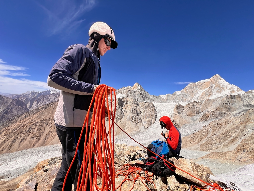
But the climb wasn’t over. We descended back to our bivy, brewed water, ate something, and started down the left-hand ridge, our planned descent route. The first section was easy snow. We were moving together on the rope. Closer to the ridge crest the angle steepened — 50° snow, poor ice, sketchy protection. Wadim took the lead, placing screws wherever possible. Soon we reached the first rock barrier and began rapping. I took over and drilled one Abalakov after another — I lost count after ten. For several hours we rappelled down the ridge crest until it was time to go straight down the face — the final 400 m, the most serious part. Luckily, our timing was perfect: dusk fell, and not a single stone came down. We swapped ice anchors for rock, rappelling down vertical granite, pitch after pitch. At 9 p.m. we touched down — out of gear, but safely back below the wall. At 10 p.m., we stumbled into ABC — exhausted but elated.

The next day we packed everything and descended 1500 m back to basecamp, where our two cooks and liaison officer greeted us like heroes.After a one day of rest and massive meals, we made one last trip up the valley to retrieve our cache which we were too wated to carry down. It was a sunny day — we lay on our mats, Dark Side of the Moon playing from a speaker, gazing up at our mountain one last time. We looked at each other — that’s it.
And that’s how our route was born:“The Great Gig in the Sky” (M6, A1, 1100 m)
Comments (0)
There is no comment on this article.
Comments can only be inserted by logged-in user.